Download a PDF of the 2015 Black Rock City Map.
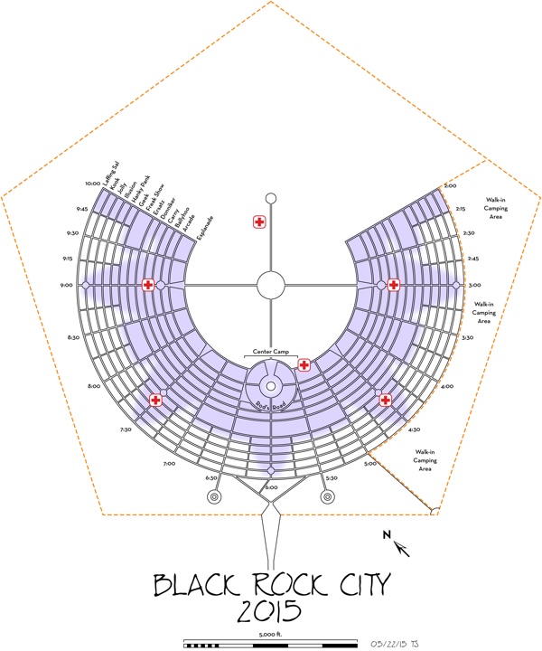
In 2015, the annular streets were named:
Esplanade
Arcade
Ballyhoo
Carny
Donniker
Ersatz
Freak Show
Geek
Hanky Pank
Illusion
Jolly
Kook
Laffing Sal
The road circling Center Camp is named “Rod’s Road” in honor of BRC designer Rod Garrett (1936-2011).
The radial streets of Black Rock City are named by their clock position. The light blue shaded area does not specify, but rather approximates, where you will find reserved-placement camps: interactive theme camps, camps supporting art installations, and infrastructure camps. We’ve softened the edges of the reserved-placement shading here as this zone fluctuates greatly between this initial city plan and the final placed camp plan displayed at the event site.
Reserved camp space is marked on the playa with blue survey flags. Some of these plots are so large that they may appear unclaimed and available, when they actually are not. Be sure to camp outside the blue flagged zones to avoid encroaching on reserved zones, and then having to relocate your camp.
All annular and most radial streets are 40-feet wide, with the exception of the short radials at the :15 and :45 time increments that run from Geek to Laffing Sal. The distance from the inner-most Esplanade street to the Man is 2500 feet. Esplanade to Arcade Street, curb to curb, is 400 feet deep. All mid-city double-deep blocks are now located between Ersatz and Geek streets, and are 440 feet deep. The remaining blocks are 200 feet deep.
NEW FOR 2015:
Three new first aid stations are placed on Hanky Pank Street behind the 4:30 and 7:30 plazas, and near the Temple, joining the medical stations behind the 3:00 and 9:00 Plazas on Carny, and the advanced level care (emergency clinic) located at Esplanade & 5:15